The Tulip System
 Before we go in the details of the widely used Tulip driving instruction system, lets first take a look at rallies in general. A rally is a competitive event with automobiles. That means that participants drive their cars and at the same time are involved in some kind of competitive activity. These competitive activities can be outright speed (what you see on TV from the WRC), average speed (a.k.a. time speed distance or TSD), gimmicks and questions (the kind that we usually have), and lastly, following the rally masters route correctly. Please note that scoring in the first three types is not based on finding the correct route. Also note that in the 4th type, participants easily get lost if they fail to find the route that the organizer had in mind. The first three types should have driving instructions that are simple, straight forward and unambiguous so that the participants get focus on the challenge of the competitive activity at hand, i.e. going as fast as possible (WRC), maintain the expected average speed (TSD) or finding the answers to questions, trivia or other gimmick activities. Before we go in the details of the widely used Tulip driving instruction system, lets first take a look at rallies in general. A rally is a competitive event with automobiles. That means that participants drive their cars and at the same time are involved in some kind of competitive activity. These competitive activities can be outright speed (what you see on TV from the WRC), average speed (a.k.a. time speed distance or TSD), gimmicks and questions (the kind that we usually have), and lastly, following the rally masters route correctly. Please note that scoring in the first three types is not based on finding the correct route. Also note that in the 4th type, participants easily get lost if they fail to find the route that the organizer had in mind. The first three types should have driving instructions that are simple, straight forward and unambiguous so that the participants get focus on the challenge of the competitive activity at hand, i.e. going as fast as possible (WRC), maintain the expected average speed (TSD) or finding the answers to questions, trivia or other gimmick activities.
Today, our clubs are only involved in the latter kind of rally, maximum or average speeds are never scored. Early European rallies used a variety of driving instructions based on written turn-by-turn directions and maps. It was very difficult to prevent participants from getting lost because of interpretation, difference in maps, and a general lack of standardization. This caused that speed or gimmick rallies turned out to be more like the 4th type; finding the rally masters route.ĀAnd in doing so, rallies got their reputation ofĀgetting lost, in-car fights between driver and navigator, and divorce.Ā
One of the famous speed scored rallies of the 50's and 60's was the Dutch Tulip Rally (Tulpenrallye) Facing the problem just described, they came up with a system of very simple sketches to indicate the directions they want the cars to follow between, and more importantly during, the timed speed sections. The Tulip system became the standard in rallying throughout the world and is used in just about every rally where finding the correct route itself is not the challenge. The Tulip folks also were well ahead of their time because GPS systems today adapted to a very similar approach. Every instruction more or less consists of 5 elements:
1) Sketch of the road situation
2) Dot to indicate from which way you approach the intersection
3) Arrow to indicate which way to follow
4) Distance from the previous instruction
5) Some landmarks, such as street names, stoplight, stop signs etc.
Here are a few examples:
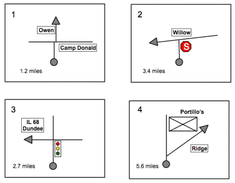
Instruction 1
In words this would be something like:ĀIn 1.2 miles go across Camp McDonald on Owen in a little bit offset intersection. You see how much easier it is to draw the offset intersection than to describe it unambiguous?
Instruction 2
Self explanatory, right? Note that the because it is clear that you're looking for an end-of-road situation, it is easy to find. Any intersection or side road on the 3.4 mile stretch can simply be ignored. The stop sign doesn't have to be drawn like it is here. You can also use an abbreviation, SS or so, as long as it is consistent.
Instruction 3
This one is clear also, isn't it? Turn left at the stoplight at Dundee Road. Just like the stop sign in instruction 2 the stop light can be abbreviated or simplified.Ā
Instruction 4
In 5.6 miles turn right on Ridge Road. Because the sketch shows the Portillo building at the intersection, you don't have to slow down and check the name of every side street on the 5.6 mile stretch. Also the orientation of the side street, angled, helps to identify the correct route easily
|